
In the previous post, I reported on the trip segment from Flintstone, GA through the Rocky Mountain National Park on our way to Boise, Idaho. We had traversed five states and part of Colorado. I’ll pick up the story as we get ready to depart Stillwater Campground on Lake Granby, Colorado, excited about heading to Moab, Utah. We begin with the 6th day of our adventure, in Stillwater, Colorado.

Trip Map Flintstone to Boise
Day 6, Aug 27: This day was perhaps our favorite long driving day on the trip out to Boise (the prior day through the Rocky Mountain National Park was a short driving day.) We got an early start on a beautiful, cold morning (being from Georgia, “cold in August” just doesn’t seem right.) After leaving the campground and taking a right turn in Granby, we soon joined the Colorado River – this time after it leaves Lake Granby. We played hide and seek with the Colorado River much of the day, pretty quickly joining it in the narrow Byers Canyon.
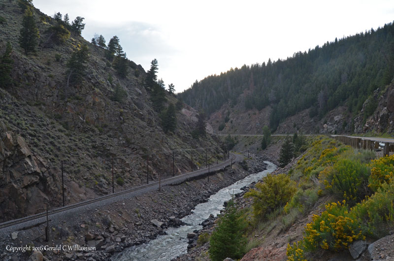
The Colorado River, Union Pacific Railroad, and US Highway 40 parallel each other through Byers Canyon downstream from Hot Sulfur Springs, Colorado
I chose a shortcut on this day when setting up the route in our car’s GPS, so in Kremmling we turned left onto SR9, cross the Colorado River once again, and then made a turn onto Trough Road. I hit the brakes and came to a stop – Trough Road is a dirt road! I was worried about washboarding rattling the trailer to pieces and had no idea if the road was worse further along, but this route really cut a LOT of miles off the day’s travel. Cindy said “The road looks pretty good; let’s try it!” so with some trepidation I headed down the road toward its crossing of Blue River, a significant tributary of the Colorado. The road was good so far, and the scenery was tremendous, so we happily motored on – at about 20-25 mph.
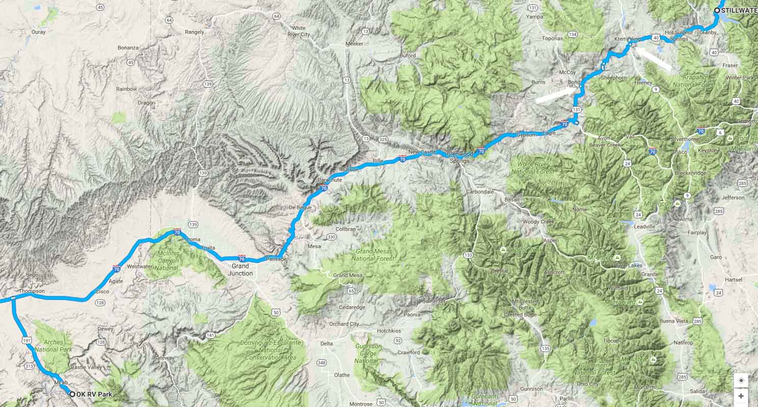
Day 6 Route – Stillwater to Moab. The white arrows in the upper right corner show the shortcut on Trough Road, from Kremmling to State Bridge (map shows Bond)
Trough Road was a fun, beautiful drive. It goes south of San Toy Mountain, while the Colorado river passes San Toy on the north through it’s self-made pathway, the 6-mile long Gore Canyon. After crossing the Blue River, Trough Road slowly climbs, and after getting around Toy Mountain, the road starts a relatively steep, curvy descent to where it overlooks Gore Canyon. We stopped at Inspiration Point and another overlook a short way down the road (a few miles paved here in the steep part.)
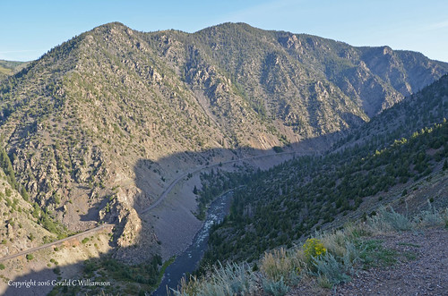
View of the Colorado River and the Union Pacific Railroad (complete with tunnel) in Gore Canyon. We saw a train coming up the valley, so we delayed our departure from the overlook and watched (and photographed) it as it went through the tunnel.
Trough Road more or less follows the Colorado River down to State Bridge, where we headed south up a 1,400′ climb and then a downhill run to Interstate 70. For its part, the Colorado River headed north a ways on the path of least resistance and then it too headed onto a southerly course. Our route on Interstate 70 followed the Eagle River until that river joined the Colorado near the entrance to Glenwood Canyon. I think this has to be one of the more beautiful 100-mile stretches of Interstate Highway in the nation as I-70 follows the Colorado River from Dotsero to Grand Junction.
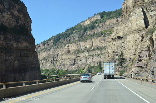
Interstate 70 in Glenwood Canyon
After Grand Junction, where the Colorado River and I-70 separate a bit as the river heads into McInnis Canyons National Conservation Area, and I-70 moves westward from Colorado into our first view of Utah. At this point we’d been on a downhill run of nearly 4,000′ to an elevation of 4,760′ at the Utah border, moving into a relatively flat, dry, open plateau. As we left the Interstate, we were on another long downhill run, however, leaving the top of the plateau, dropping to about 4,000′ in Moab, where our path once again crossed the Colorado River as it crossed Spanish Valley. We ensconced ourselves at the OK RV Park on the south side of Moab (it’s really interesting how many RV parks are “OK”), to rest up for exciting visits to Arches and Canyonlands National Parks over the next few days.
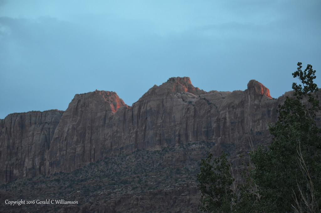
Sunset on the plateau rim above Moab, Utah from OK RV Park. We’re clearly no longer up on the plateau like we were while on I-70.
Day 7, Aug 28: Let the Moab adventure begin! I had heard of Moab over the years generally as a great outdoor destination, especially related to mountain biking, but I didn’t really know anything specific about it. For example, I didn’t know if it was an area known as “Moab” (as in “Painted Desert”), or a specific location. Until I was map-following three of my grandchildren (Ethan, Sam, and Sydney Ibach) as they made a trip to Yosemite and back – back with a sidetrip to Moab – I didn’t know that Moab is a city; didn’t even know Moab is in Utah. With the Ibach’s enthusiastic endorsement, Moab and the nearby national parks – Arches and Canyonlands – became a firm destination on our trip out west. Our planned itinerary for Moab was to spend 2 days at the OK RV Park, where we had electricity, and one night at Arches National Park’s Devil’s Garden Campground. Based on that plan, we chose do “do” Canyonlands National Park our first full day in Utah, so we headed north out of Moab, past the entrance to Arches National Park, and after several miles made the left turn onto SR313 into the mouth of the South Fork of Sevenmile Canyon.
The entrance to South Fork Sevenmile Canyon bode well for a day of majestic views.
The road soon made a couple of switchbacks up the south face of the canyon to the top of the plateau, where there was an overlook / trailhead. More great views, including a couple of buttes called “Monitor” and “Merrimack.”
Monitor and Merrimack
Once on top of the plateau, it was a relatively flat drive through the Utah desert with more or less distant views and the occasional interesting side-road, such as that to Horsethief Campground that we passed with only the wish of future exploration. Those side-roads that we passed also included the road to the oddly named (and I hear quite interesting) Dead Horse Point State Park, where SR313 headed. Our road to Canyonlands now become Grand View Point Road, aka Island in the Sky Road. Eventually we entered the National Park, the entry being about as far south as where we started the day in Spanish Valley but several miles west. Our first stop in the park was Shafer Canyon Overlook.
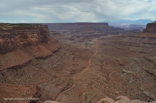
Canyonlands National Park Shafer Canyon Overlook – Shafer Canyon Road below.
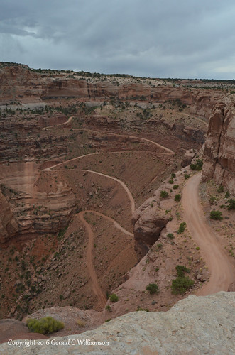
Shafer Canyon Road is not for the faint of heart…
Moving on, we enjoyed the sights, and decided to make the .6-mile round-trip walk out to Mesa Arch. Cindy’s asthma had not been treating her well since spending some time at high altitudes in the Rocky Mountains, but she was able to make the walk to the arch. Well worth it. There were quite a few other people who were hanging out around the arch, so we had a hard time photographing anything without people included.
Cindy finally spoke to some folks who had already been in front of the arch for a while and had completed their selfies, asking them if they’d mind moving out of the picture for the half-dozen or so photographers who were waiting for a clear photo. They kindly agreed.
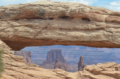
Mesa Arch, Canyonlands National Park – after waiting for a clear shot.
We continued out Grand View Point Road, making several stops before the end of the road at Grand View Point Overlook. Down below was once again a canyon of the Colorado River.
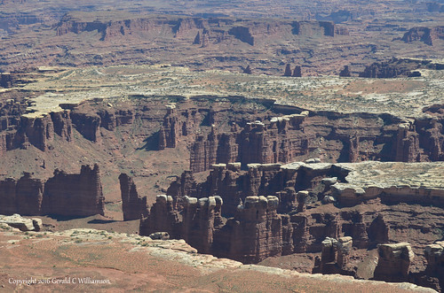
Canyon of the Colorado River from Grand View Overlook in Canyonlands National Park
After the grand view at Grand View, we headed back north. We had some time, so decided we’d see what Whale Rock looked like (we had a guess.) Unfortunately, I must not have taken a photo of said rock, but that’s OK, because more noteworthy to us on that side road was the Aztec Butte stop. Cindy’s asthma was acting up in the heat, so she couldn’t hike with me, and I didn’t want to leave her behind for too long, so I didn’t make the full hike to Aztec Butte to see the Pueblo structure there, but I did make the shorter (1/2 mile round trip) hike to the Pueblo granaries on Lower Butte. This was pretty exciting, since it was my first encounter with ancient (approx 700-yr old) Pueblo Native American structures.
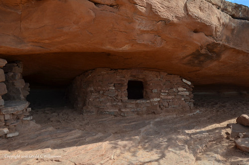
Pueblo Granary at Lower Butte is about 4 feet high
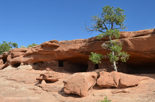
When I made the prior photograph, I didn’t notice the second granary to the left under the roof.
When I made it back to the car, Cindy and I knew that the heat was making her asthma untenable, so when we got back to OK RV Park, I checked with the office and extended our stay for another day. Unfortunately this meant we would not be able to stay at Devil’s Garden Campground in Arches National Park – we needed electricity for air conditioning. But that also meant a relaxing evening without needing to prepare to move the trailer the next morning. After the great day in Canyonlands, I was more than willing to relax for the evening.
Day 8, Aug 29: How do you top a great day in Canyonlands National Park? Do what we did – head out to Arches National Park. The entrance to Arches is just north of Moab on US191 on the southwest corner of the park. This is a popular park, so expect a bit of a wait on your entry to pay the $25 per car fee – or if you’re an oldster like us, have your Senior America the Beautiful Pass along with ID and get in free. A stop at the nearby visitor center is worthwhile for the exhibits, maps, and video presentation. I went to the ranger desk to tell them I was going to release my (coveted) reservation for the night at the campground; that we would just use it for a lunch/rest stop in the afternoon, and would not be staying overnight. The ranger seemed really appreciative and told me to tell the campground host when I got up there. We got back in our car and started the steep ride up the side of the canyon to the top of the plateau.
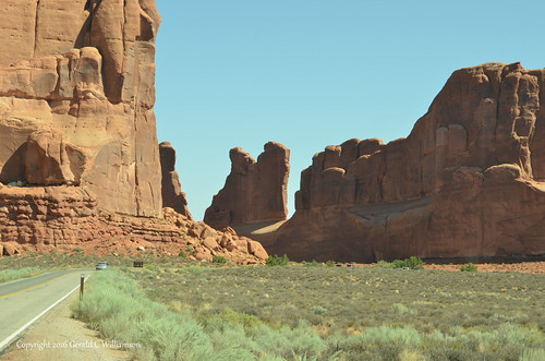
Our first stop after reaching the top (other than a quick pull-off) was at the Park Avenue Viewpoint. Park Avenue is a relatively short trail – just under a mile – through the Courthouse Towers formations.
View to Park Avenue Trailhead; I wanted to include this to provide some scale context – you can see the car in the road ahead.
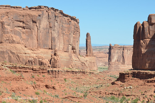
Park Avenue runs down this canyon in the Courthouse Towers area, Arches National Park. The Tower of Babel is the distant formation in the right-center.
I chose not to walk the .9-mile Park Avenue Trail, and by skipping that walk our next stop was at The Organ (I think I have the formation name correct.) After stopping for sunrise over The Organ (11:30 AM), we passed the north trailhead of Park Avenue Trail and made a stop at Courthouse Wash, where I photographed a few wildflowers, including a Wyoming Indian Paintbrush.
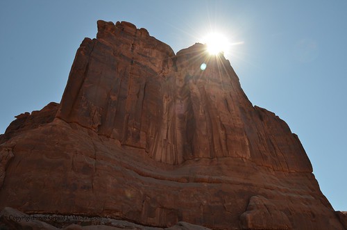
Sunrise over The Organ – Arches National Park
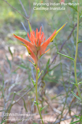
Wyoming Indian Paintbrush – Castilleja linariifolia
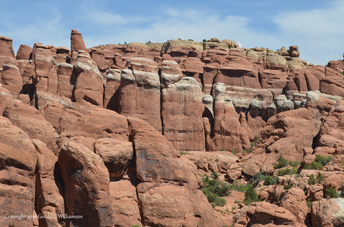
Next we drove past the Petrified Dunes area and the area the map generally describes as “Rock Pinnacles” to reach a crossroads at one of the parks more recognizable features – Balanced Rock. As a side note, ravens were persistent during out time out west, especially starting here, and for the rest of our trip until we got back to Arkansas we saw ravens at nearly every location we visited.
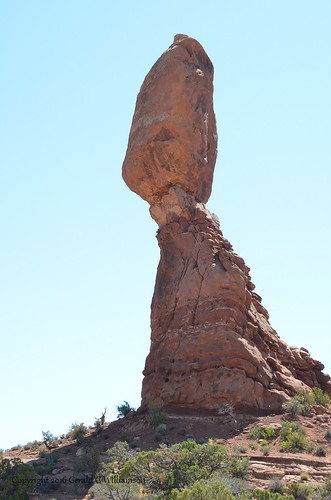
Balanced Rock, Arches National Park
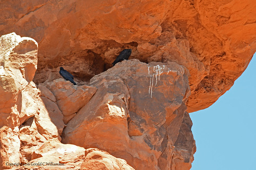
Ravens nesting on Balanced Rock, Arches National Park
After grabbing some lunch at the nearby picnic area, we made side trips to see Double Arch and Delicate Arch, and stopped along the main road pull-offs for visits to Fiery Furnace and Sand Dune Arch. These arches are also very popular landmarks, and in this busy season it was nearly impossible to get photos without including people. We also got a “frontside” view of Skyline Arch as we drove by.
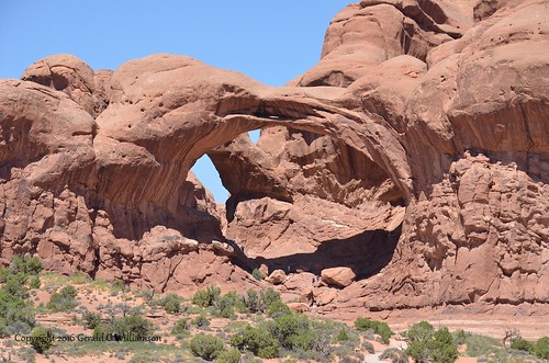
Double Arch, huge and very popular landmark in Arches National Park
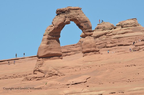
All those people took a nearly 3 mile (round trip) hike to Delicate Arch at Arches National Park. Photograph is from the shorter (.8 mile) lower viewpoint, plus a bit of a hike past the official end of the viewpoint trail.
You can sign up (and pay) for a hike into the Fiery Furnace, Arches National Park
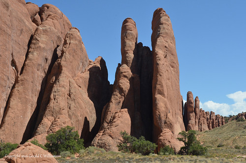
The slot between a couple of those fins provide access to Sand Dune Arch
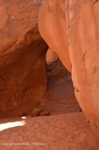
Sand Dune Arch – not having done my research, I didn’t bring my wide lens into the slot – bad mistake.
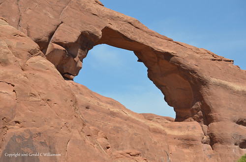
As we neared the end of the road, we passed by the front side of Skyline Arch
We shortly reached the entry to the Devil’s Garden Campground, which would have been our destination for the day if it wasn’t so hot (it was over 90 degrees) and we needed shore power for air conditioning. I stopped at the campground host site to release our campsite, but they weren’t in so I just left a note. Then we drove on through the campground to see what we were missing. Oh. My. Goodness.
Yes, there are some fantastic views from the Devil’s Garden Campground

Skyline Arch is right there by the campground Amphitheater
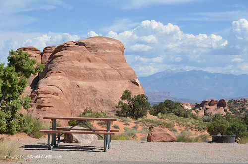
This would have been our campsite (#4) if we had chosen to stay at Devil’s Garden Campground
A bit wistfully, but in agreement that in this heat we had made the right choice, we left the campground, drove around the loop past the entrance to the Devil’s Garden Trail, and headed back to OK RV Park in Moab.
Entrance to Devil’s Garden area of Arches National Park. We didn’t hike the approximately 5 miles of Devil’s Garden trails that would have allowed us to see 8 more significant arches. Maybe another trip…
Stay tuned for Part Three of our adventure, Moab to Boise.